Many mefarshim ask why in Parashas Emor, in
the verses about the different chagim, there is an insert about the mitzvah of
leket, peah and shichecha, inbetween the verses discussing Shavuos and the
Yamin Nora’im. Rav Baruch Rosenblum saw in an old sefer the following
explanation: The insert about these land related mitzvos alludes to the 9th of
Av, which falls between the two aforementioned chagim. These three commandments
instruct us to leave over produce in our fields. Hashem keeps Torah and His
field is Zion
(Har HaBayis) when Tzion (Har Habayis), was ploughed over, Hashem kivyachol
left over the Kosel, a heavenly leket, peah and shichecha.
 The Kosel is the biggest makom tefillah in
the world, and millions of people from all walks of life visiting it each year.
The Kosel (i.e., the open section, which people refer to as the Kosel) comprises
only 60 meters
of the 488 meters
of the western retaining wall of Har Habayis.
The Kosel is the biggest makom tefillah in
the world, and millions of people from all walks of life visiting it each year.
The Kosel (i.e., the open section, which people refer to as the Kosel) comprises
only 60 meters
of the 488 meters
of the western retaining wall of Har Habayis.
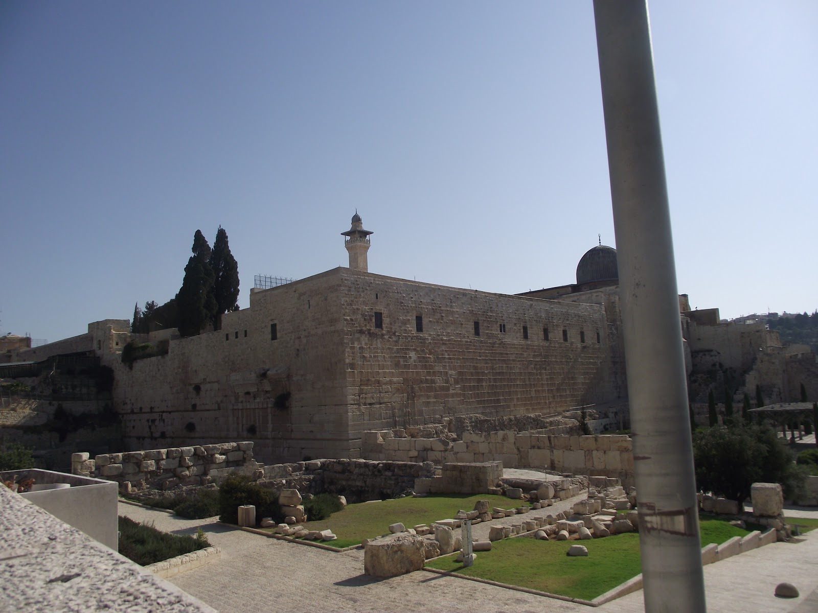
The first section of the Western Wall runs
from the south-western corner of the Temple
Mount until the Mugrabie Gate and is
found today in what is called the Davidson
Center, and is part of
the Southern Wall Excavations. Here the wall has been exposed to the level of Second Temple street
(paved by Agripas II), which street runs alongside it.
 The rest of the Western Wall is found
within the vaults and arches of the Kosel Tunnels. In this column I would like
to take you on a guided tour though these fascinating underground labyrinths.
This will be an awe-inspiring journey through time; enthralling lessons in
Jewish history will be learned, and the archaeology and topography of
Yerushalayim will be studied.
The rest of the Western Wall is found
within the vaults and arches of the Kosel Tunnels. In this column I would like
to take you on a guided tour though these fascinating underground labyrinths.
This will be an awe-inspiring journey through time; enthralling lessons in
Jewish history will be learned, and the archaeology and topography of
Yerushalayim will be studied.
The Donkey Stable
We enter though the arched doorway into a
room that was built at the end of the Middle Ages, and that British explorer
Charles Warren called “The Donkey Stable.” Here we stand around a half-circle
model of the topography of ancient Yerushalayim (before it was called so), as
it looked after Creation. The place of Har Hamoriah is represented. Here we find
the even hashesiyah, the embryonic stone from which Hashem created the world.
Here the first man was created. The place of the altar is in very close
proximity to the foundation stone.
We are told by Chazal “Makom hamizbe’ach
mechuvan b’yoseir.” The altar’s location must be exact, as this is the very
spot on which Adam Harishon built his altar and sacrificed. Here Kayin and
Hevel also brought their gifts to Hashem. It was here that Shem sacrificed an
offering, in Noach’s stead, after the Mabul. Noach had been crippled by the
lion when he had delayed bringing the animal its food and consequently was
passul from being able to bring up korbanos. It was here that Avraham Avinu
withstood the greatest of tests and was ready to sacrifice his beloved son
Yitzchak, all for love of Hashem.
Shmuel Hanavi and Dovid Hamelech learned
all night and discovered that this would be the place of the future Beis
Hamikdash. Dovid captured the city from the Yevusim and bought the place of the
Temple Mount for good money. Dovid was not
allowed to build the Beis Hamikdash, but he prepared everything for its
construction, down to its finest detail. He even wrote the songs the Levi’im
would sing in it each day.
Shlomo, the son of Dovid, built the first
BeisHamikdash, which stood 410 years. It was destroyed by the Babylonians.
Seventy years later the Jews returned and rebuilt the second Beis Hamikdash.
Herod (born 73 or 74 BCE, died 4 BCE)
reconstructed the Temple
in a most magnificent fashion, as an atonement offering for having killed the
chachamim. At that time he enlarged the area of the Temple Mount
to the north and to the south and built strong retaining walls. As the Antonia
Mount to the northwest of Har Habayis was in the way of the enlargement, he
shaved it and rolled its stones downward to the south, where he used these
stones to fill in the southern part of the area that sloped downward.
This splendid building of the Beis
Hamikdash stood till 70 CE when, to our great pain, it was destroyed by the
Romans, who built a pagan temple in its stead. The years passed and when the
early Umayyad Muslims ruled in Jerusalem,
they built the Dome of the Rock in 691 CE. The Crusader king Frederick II of Hohenstaufen
was crowned as king of Jerusalem
on 18 March 1229. At that time the city was divided in two.
When the Crusaders were eventually
vanquished, the Mamelukes claimed that the reason the Crusaders were able to
divide the city was because the upper city was separated from the Temple Mount
by the Tyropoeon Valley
(Cheese-Makers Valley). They therefore built a
labyrinth of arches and vaults and raised the level of their homes so they
could have close direct access to the Temple Mount.
The Kosel Tunnels were dug beneath these arches.
 The ‘Secret Passage’
We now enter the Secret Passage that is
named for a fanciful Medieval legend that Dovid Hamelech used this underground
walkway to travel unseen from his palace to the Temple Mount.
The citadel that the myth claims as Dovid’s palace is actually a Crusader
castle, even though it is now what we call Migdal Dovid.
The vault system you walk through consists
of the arches the Arabs built in the latter part of the 13th century. At that
time, the vaults were sealed in order to create water cisterns. Looking upward
you see a huge arch with openings in the stonework so that those dwelling above
could lower vessels into a water supply directly under their houses.
During the Second Temple times, there stood
an arch that spanned 42 feet
and supported a road (bridge) that ran 75 feet above the Herodian pavement and Tyropoeon
Valley below, and is today called Wilson’s Arch (after Charles Wilson, a 19th
century explorer of Jerusalem). The road atop Wilson’s
Arch gave access to a gate that was level with the Temple Mount
during Herodian times. The surviving top of this arch is supported against the
Western Wall. (It is believed that Wilson’s
Arch was the first of a series of arches that continued westward. A number of
arches were subsequently discovered in recent years.)
Josephus mentions the bridge that this arch
was part of and says it connected the Temple
Mount to the upper city on the Western
Hill, on the other side of the Central Valley.
The bridge carried water, through an aqueduct, to the Temple Mount
from Solomon’s Pools. Josephus
also claims that the Jews themselves
destroyed the bridge in order to curtail the Roman advance to the Makom
HaMikdash during the Churban.
 In the 130s CE, tragically, the Roman
tyrant Hadrian transformed Jerusalem
into a center of pagan worship and renamed it Colonia Aelia Capitolina. The
Romans rebuilt the bridge, using two parallel arches for support instead of the
one original arch.
In the 130s CE, tragically, the Roman
tyrant Hadrian transformed Jerusalem
into a center of pagan worship and renamed it Colonia Aelia Capitolina. The
Romans rebuilt the bridge, using two parallel arches for support instead of the
one original arch.
In 2005, the Western Wall Heritage
Foundation under the Rabbi of the Kosel, Rabbi Shmuel Rabinovich, initiated a major
three-year renovation effort. The arch was strengthened so that people could
come and use the Wilson
area to pray in. Today there is a shul, with a women’s gallery, under the
Wilson Arch.
Glass Window Showing Mikveh
Standing in the hall (dubbed the Bar
Mitzvah Hall) that is under the Wilson Arch Shul, one senses being underground.
However, if one looks down into the glass window in the floor — near the wooden
steps one just came down — it will be seen that at least 12 meters had been dug
out beneath, to reach ground level. At the bottom of this pit one can see a
First Beis Hamikdash period mikveh. The laws of tumah and taharah were adhered
to stringently when the Beis Hamikdash was in existence. Many mikvaos have been
discovered in the area.
Two levels below is the Mikveh Hall, with
remains of a keilim mikveh (whose water source is in Ir David) and two other Second Temple
mikvaos. One of them is full of water, and is used nowadays by many chasanim to
tovel on their wedding day. The Islamic world has been denying that there was a
Beis Hamikdash on Har Habayis, but the existence of literally hundreds of
mikvaos in the area — and the ones seen here so close to the Temple Mount
— disprove their spurious allegations.
 These mikvaos show that we were here and
kept all the halachos connected with taharah and tumah that were needed to
enter and perform the avodah in the Beis Hamikdash which stood on Har Habayis.
The Chashmona’im room is found on the same level as the Mikveh Hall.
These mikvaos show that we were here and
kept all the halachos connected with taharah and tumah that were needed to
enter and perform the avodah in the Beis Hamikdash which stood on Har Habayis.
The Chashmona’im room is found on the same level as the Mikveh Hall.
The Chashmona’im Hall
The Chashmona’im Hall is part of a group of
constructions from the Second Beis Hamikdash era, which are located very close
to the Temple Mount. So far, three halls have been
found and were numbered 8, 9, and 10, 10 being the Chashmona’im Hall. At the
time they were built, it seems that they were all open to their southern side.
It is not known what function these rooms
served, but for the reasons stated below it is thought by some that they were
used for a kodesh purpose. Firstly, the outside wall (found in the Mikveh Hall)
of the Chashmona’im Hall has beautiful, large, framed stones. These are found
in only three other sites, all of which were used for holy purposes — Alon
Mamre, Me’aras Hamachpeilah, and Har Habayis. Secondly, all the gates of the
Beis Hamikdash had double (or triple) entrances and this hall has a double
doorway.
Others say that because the bottoms of the
walls of these three succeeding chambers were covered in waterproofing, it
could be that they were part of a large bathhouse complex. Behind area 9, an
enormous water cistern was found. On the back wall of this room are beautiful,
square columns with intricately carved capitals that have holes in them, which
might have served as fountains.
Although this room is called Chashmona’im
Hall, it is actually from the Herodian period. The reason it is called the
Chashmona’im Hall is that it was opened to the public on Chanukah. Another
reason for this name is that Charles Warren named the hall “the Masonic Hall”
since he was a Freemason and the Freemasons met in this hall. The name “Chashmona’im
Hall” sounds similar to its English name.
The stones of the walls of these rooms have
a unique dressing, consisting of Herodian frames of delicate “margins” and
smooth “bosses.” On the back wall of the Chashmona’im Hall one sees a
decorative cornice that originally ran the whole way around the room. It seems
that this type of “shelf” was also part of rooms 8 and 9, as delineating marks
are seen in them.
Above the cornice in the Chashmona’im
Hall,behind glass, one sees ball-like stones. These are catapulting stones, the
ancient equivalent of artillery, which were probably launched by the Romans
during their attack on Yerushalayim in 70 C.E., and later against the Bar Kochba
rebellion in 132 C.E.
Behind this glass one can also see the “heart
wall” that runs through all three rooms and which supported the road leading up
to the Wilson Arch. Viewed in the centre of the room is a Corinthian pillarthat
was brought into the room during the Middle Ages to support the ceiling, which
had been damaged during the course of time.
Also seen is a modern-day iron support.
Golda Meir came to visit the Chashmona’im Hall and was fearful the ceiling
would collapse on her head. So this piece of metal was installed before her
visit to allay her fears.
The back wall of the Chashmona’im Hall is
Roman. Right behind it is the Hall of Ages.
The Hall of Ages
This chamber is about 7 meters in length and 4
to 5 in width,
and is more than three thousand years old. It was opened to the public in 2009
and is called the “Heichal Hatekufot,” or the Hall of Ages, because it contains
archaeological finds from different ancient periods.
After the Six Day War, as the Kosel tunnels
were being dug and investigated, safety experts and engineers warned that one
small enclosed area adjacent to the Herodian Hall was in danger of collapsing
and could cause all the tunnels to collapse. Consequently, this space was
filled in with cement and areas around it were explored in its stead.
As work progressed, the whole system of the
tunnels was strengthened, and eventually it was determined that the cemented
area could be dug out. Window-like holes were made in its frontal wall … and
the Hall of Ages was unearthed.
In the Hall of Ages, one encounters the
historical timeline of Yerushalayim — spanning more than three thousand years
until the current day. Standing on the wooden deck around the sides of the
vault, you look over a waist-high bar into a large, gaping hole. The floor of
this pit is a First Beis Hamikdash era street with asmall water hole, maybe
from the time of Chezkiyahu, or even earlier.
On a slightly higher level in the cavity is
a large Chashmona’im water pool that is 28 meters by 28 meters. (A similar one
is found in Beit She’an.) One can also see a Herodian wall in the pit. The
frontal wall mentioned earlier is from Roman times. On one of the side walls is
the early Muslim period entrance. Toward the rear of the pit, one can see a
Crusader arch balancing on the side and crowning the other findings. While the
digging was in process, this arch disintegrated and had to be reconstructed.
Although most of the roof is modern-day
21st century cement, the section over the doorway is a Mameluke arch and holds
up the Arab Macrmay (law court) building above it, which is seen from the Kosel
and is now a police station. The back wall of this room is from the 21st
century.
Second Temple Model
Returning to the Bar Mitzvah Hall level,
one can see that the table and chairs in this area are transparent, in an
attempt to make them as inconspicuous as possible so as to preserve the ancient
atmosphere. Behind a false stone is a computer that shows what is going on at
the Kosel Tunnels.
Entering though a grated iron gateway, continue
walking along the narrow wooden boards to reach a model of the Second Beis
Hamikdash created by Reb Zalman Menachem Koren. Here we will sit and we will
view the model and hear an explanation on the whole area.
to be continued
Nidbach Raba
After the Second
Temple model, descending the steps,
one can see a row of four huge stones, the largest building stones ever
discovered in Israel.
Many claim that they are the largest building stones ever used in world
history. These gigantic stones — with a Herodian frame of delicate “margins”
and smooth “bosses” — are referred to as the “Nidbach Raba” or “Master Course.”
They were built by Herod and lie nine rows above the bedrock.
The largest of the four, the “Western
Stone,” is a solid piece of hewn limestone almost 45 feet long (13.6 meters) — the
length of an accordion bus — and over 10 feet high (3.15 meters), and
estimated from between 11 to 15
feet deep (3.5 to 4.5 meters). It weighs
more than 570 tons, the weight of 67 large African elephants, and is one of the
heaviest objects ever lifted by man without powered machinery.
The next-largest stone of the four is 40 feet (12.6 meters) long.
These master stones are covered in
rectangular holes, as the enormous four-winged room where they were found (and
in which they are now) had been turned into a large cistern prior to the 13th
century. The whole area, including the retaining western wall of the
Temple Mount, had been
plastered over so it could retain water.
As the smooth Herodian Kosel stones are not
suitable to hold cement, these square holes were carved out of the wall of the
Kosel, into which protruding square stone pegs were set. A thick, rough wall
was built adjacent to the Kosel around these pegs, which acted as stabilizers. This
“rough wall” was then plastered over.
Holy of Holies Shul and the Warren Gate
From the Nidbach Raba the Kosel Tunnel runs
north for more than 1,115
feet [340 m] alongside the Western Wall and cuts its way
under the shops and houses of the Arab section of the Old City of Jerusalem.
About 150 feet (46 m) within this tunnel lies
a blocked gate. The gate was called Shaar Yehudah during Temple times and is now referred to as the
Warren Gate, after 19th-century British archeologist Charles Warren, who conducted
extensive explorations of the Wall around 1867.
During the Second bbais Hamikdash, the Temple Mount
plaza was much higher than the street that ran along the western retaining
wall. The Warren Gate led into an underground passageway that led up into the Temple Mount.
(Even nowadays, on the other side of this
now-sealed gate are a tunnel and a staircase of 15 steps that lead up to the
surface of Har Habayis.)
As the gate was 18 meters above street
level, there was a terrace in front of it which was reached by steps. Today,
the floor of this terrace is still composed of original paving stones from the
Herodian street that ran parallel to the Western Wall (Wall Street).
When the Temple was destroyed, this gate was
abandoned. Around the year 638, when the Muslims under Rashidun Caliphate
conquered Jerusalem
from the Byzantines, Jews were permitted to establish a synagogue near this
gate.
It was the main shul of Yerushalyim of that
time and was known as Ha’maarah or “the Cave.” There are documents in the Cairo
Genizah, testifying about the use of the Cave.
In 1099 Crusaders captured the city and
annihilated the local Jewish community by sealing them in this shul and burning
them alive. The Crusaders turned the arch space into a cistern.
Around 1187, when Saladin recaptured the
city, the whole area was covered over and became completely inaccessible.
For centuries Jews dreamt of returning once
again to the site of Ha’maarah and being again able to pray at this entrance to
the makom haMikdash, opposite the Holy of Holies. After the Six Day War,
Rabbi Yehuda Getz, z”l, concretized this dream and opened a small synagogue,
also calling it “the Cave,” opposite the sealed-off Warren’s entrance.
Nowadays the indented, sealed Warren’s Gate is viewed
behind a waist-high glass fence. The top of the gate is covered in glass
through which one can see the Chamfers (a shallow-cut edge, or groove, usually
at an angle of 45 degrees to a corner) at the gates’ corners.
The Even Shesiyah, the place of the Kodesh
Kodashim, is 14 meters
long and is now found, to our great pain, under the golden Dome of the Rock.
Slightly further down the Kosel Tunnels from Warren’s Gate, and up three steps,
is the place where many come and pour their hearts out, since it is assumed by
many to be (together with the Warren Gate), the closest point a Jew can get to
the Kodesh Kodashim today. If one examines the wall at the back of this
enclave carefully, a natural map of Eretz Yisrael formed by the moisture of the
place, is seen. The stone in the middle of the archway is moist, as if Hashem
is softly crying in sympathy for all the pain of Klal Yisrael and with those
who daven in this place, which is literally at the gates of prayer.
1033 Earthquake
A letter found in the Cairo Genizah told of
an earthquake in the year 1033 that destroyed 60 amos (cubits) of the Western
Wall and asking for funds to restore it. It seems that this is the section
where the wall was rebuilt.
The Tunnel
At this point, continuing along, one enters
what is known as “the Tunnel.” This very long, straight passage was originally
an open promenade (Wall Street) along the entire length of the Western Wall of
the Temple Mount. Every effort was made to maintain
the structural integrity of the buildings above, while revealing the full
length of the Western Wall.
As you walk along, you will note that these
stones were perfectly preserved by their remaining underground for hundreds of
years. Each row of stones is slightly set back from the row beneath it. Thus,
the illusion of a perfectly straight wall is attained. Paradoxically, had the
stones been exactly aligned, the wall would have appeared to be leaning
forward.
The modern-day iron pillars holding up the
roof of the Kosel Tunnels do not touch the Western Wall because of their kedushah.
Some say that the wall to the left is a First Temple
wall from the days of Shlomo
Hamelech.
Walking along, you will reach a glass floor
window. Looking down, your heart will contract in pain upon seeing the fallen
stones from the Churban. Walking further brings you to a second glass window
that showsthe bedrock below.
to be continued
Herodian Street
Square
During the times of
the Second Bais Hamikdash, the Herodian Street Square promenade ran the full
length of the Western Wall (Wall Street!), with many shops on either side. Here
people would buy animals and birds for
korbanos, and other necessary items.
Moneychangers were also found here.
On the wall opposite
the Kosel are two columns that are presumed to be an entrance to a shop. The vault
system above was built in the 14th century.

The well-planned,
paved stone flooring beneath is from Herodian times. Why one huge paving stone
was never incorporated into the floor is up for conjecture. The street had
gutters to carry away rainwater.
Here the bedrock of
the Western Wall that rises above the Herodian
street level has been edged and chiseled to look
like the building blocks used in building the Herodian Western Wall.
Quarries
Where did the original
stones for the whole Wall come from? At first it was believed that Herod quarried
his stones from Tzedekiah’s Cave, north of the Old City.
But when the quarry to the left was discovered, it was immediately seen that
the stones being carved out matched the average size of those of the Western
Wall. Today, most historians conclude that most of the stones of the
Western Wall were
taken from this area.
Cistern
Throughout the centuries,
different aqueducts, pools and cisterns were made to divert, channel and hold
water for the city and the Bais Hamikdash. On this tour of the Tunnels, one explores
three waterways that brought and held water for the people, the Bais Hamikdash,
and their needs. First, there is an ancient Chashmona’I water cistern. Next is
a Chashmona’i aqueduct that brought water to the cistern near and under the Temple.
Chashmona’i Aqueduct
After the square,
one turns left into the ancient Chashmona’i aqueduct. And finally, we reach the
“Struthion Pool,” which dates back to Herod’s time. Continuing along the “Tunnel,”
one approaches the Northwest Hill, where the street starts to rise upward.
Here, at the end of the first Bais Hamikdash, a fortress called the “Baris” or “Tower of Chananel” was built. This fortress is mentioned
in Nechemiah.
The Baris was used
as a palace by the Chashmona’im. The waterworks underneath the fortress were
praised in a 3rd century B.C.E. source. Underneath the fortress were cisterns used
by the people in the fortress. When Herod enlarged Har Habayis northward, he levelled
the Baris and actually dug into the bedrock, making it level with the rest of
the Mount. Nothing was left of the Baris except the water cisterns underneath,
which Herod used. Water is, obviously, a priority to enable living in any area,
and maintaining a consistent water supply in Yerushalayim has always been
challenging.
Herod kept part of
the cistern as a reservoir for rain, but covered up the rest with the street
that ran parallel with the wall. In order to ensure that people wouldn’t fall
into the cistern, he installed a large guardrail. To one’s left is the cistern
and the guardrail, and to the right is the original stairway leading down into
the cistern.
The tunnel twists
and turns, and at last, covered by a large stone arch, leads to a reservoir
pool.
Antonia Fortress And
the Struthion Pool
Before the pool that
served as a moat for the north-western corner of the Antonia Fortress was
constructed, the aqueduct
ran from the north into this area, servicing the city and Har Habayis. On expanding
the Temple
area, Herod blocked off the southern side of the aqueduct, and the pool was split
into two parts. The southern section no longer had any function, but the
northern section continued to bring rainwater into the pool.
The Bar Kochba
revolt ended in defeat in 135 C.E.
The Roman Emperor Hadrian turned the entire pool area into a marketplace. They
covered the pool by first dividing it into two, with a wall along its length.
They then placed two arches fanning out in opposite directions from this wall.
A square platform which served as a marketplace was built on top of these
arches.
In the 19th century,
when the foundation for the Convent of the Sisters of Zion was being dug, they discovered
the ancient pool and aqueduct. To prevent strangers and explorers from entering
their convent from underground, the nuns had another wall built, splitting the
pool again, width-wise,

Only the northern
side of the Struthion Pool can be seen, as going into the convent causes halachic
problems.
At this point, one
will have reached the end of the excavations.
In September 1996,
the exit through a small tunnel leading up to the Via Dolorosa was opened, thus
affording thousands of additional tourists access to the Tunnels.
Days of violence
followed, sparked by angry Palestinians claiming that this change in the
Tunnels had involved
excavating under the Dome of the Rock. Tragically, many people on both sides died
because of this lie.
The Tunnels are not
located under the Temple
Mount or any other site
Muslims consider theirs.
As one leaves the
dark developing calm of the Kosel Tunnels, one exits through the modern turnstile—so
out of place among the history-laden ancient stones.
Now is the time to take
a moment to consider the miracle of the survival of the Western Wall, the place
about which Hashem promised that His Shechinah will always reside.


 When the recruits arrived, they lived in
tiny, square tin shanties that were broiling hot in summer and freezing cold in
winter — not to mention the icy rain that poured in
at that time of year. And the mud — the mud was everywhere and
so, so deep. A true story is told of how one tall resident became very short
within moments. He sank into the treacherous mud until his beard was level with
it. He needed to be pulled out by donkeys …
When the recruits arrived, they lived in
tiny, square tin shanties that were broiling hot in summer and freezing cold in
winter — not to mention the icy rain that poured in
at that time of year. And the mud — the mud was everywhere and
so, so deep. A true story is told of how one tall resident became very short
within moments. He sank into the treacherous mud until his beard was level with
it. He needed to be pulled out by donkeys …